A North Western bus is pictured at Whitehough in the 1950s. In the background is the Old Hall Hotel. Route 88 operated between Chinley and Kettleshulme. Only the occasional journey passed through Whitehough.
On the road from Chapel to Hayfield. The winter of 1939 and 1940 was one of the most severe on record. On 23rd January, a temperature of -23.3C was recorded in mid-Wales. Snow started falling on 26th January and continued for three days. As can be seen in this photograph, the snow had receded from the hillsides but remained piled up at the roadside.
Chapel-en-le-Frith in 1941. Members of the A. R. P. and St. John's Ambulance Brigade pose before their new ambulance.
Not in High Peak but near enough to be of interest. The Bollington bus is photographed at Water's Green in Macclesfield in 1935. In the background is Central Station and the railway bridge over Buxton Road.
Bugsworth Toll Bar. This was situated on New Road at the point where the track leads down to Britannia Wire Works. Tolls were imposed in 1864 and continued until 1919 when the council assumed responsiility for the road.
A pre-was view of Buxton with the Crescent and Pump Room in the background. The bus is waiting to depart for Macclesfield. Bath chairs wait for passengers at the foot of the Slopes.
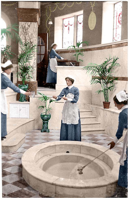
Inside the Pump Room in the 1920s. Attendants fill glasses for patrons who are "Taking the waters"
Buxton Opera House in 1923. The entrance to the Pavillion Gardens is on the left and on the right is the Old Clubhouse. The tower of St. John's Church is in the distance.
An express passes through Buxworth Station in 1953. Only the occasional train stopped here and the station closed in 1958. The station building survives and is owned by Burnage High School who use it as an outdoor centre.
The Cat and Fiddle in the 1920s. The bus pauses on its journey from Macclesfield to Buxton.
he 18th Century stocks still stand in Chapel-en-le-Frith's Market Place alongside the Market Cross. Behind is the Roebuck Hotel. A house was built here in the 13th century for the Duely family. Rebuilt in 1700, it became a beerhouse in 1720 known as the New Hall. Between 1750 and 1850 the building served as a court house until becoming the Roebuck
Disley Station in the early 20th century. Staff stand waiting for the arrival of a train from Manchester.
Disley signal box and station in the 1960s. The sidings are still in place and the original station buildings still stand. Diesel trains took over the Manchester to Buxton services from the late 1950s.
Shunting at Disley in August 1958.
Fountain Square, Disley in 1909. Plenty of action in this photograph apart from the gathering of children.
Dyehouse Lane in New Mills. Five pubs are visible in this photograph as well as the lodging house and the Drunkard's Reform.
Fernilee Toll Bar in 1939. This style of toll cottage was very common with windows arranged to give a view of approaching traffic from every direction. Long Hill was part of the Manchester to Buxton Turnpike road.
Glossop Gas Works was established in 1845. The Glossop Gas Company was nationalised in 1949 and production cesed in 1957.
This photograph of Arundel Street is from 1935
The stepping stones at Goyt's Bridge in 1914. The Goyt Valley has long been popular with visitors although this hamlet now lies below the waters of Erwood Reservoir.
Mr Brennand's Bakers cart stands outside of Bank End Farm on Kinder Road, Hayfield, Derbyshire. Mr Brennand had a bakers and confectioners shop in Church Street. The photograph is dated 1910.
Hayfield, Church Street in the 1950s
A train arrives at Hayfield station where some boxes wait to be loaded into the guard's van.
George Taylor's milk float passes the Hearse House in Chapel-en-le-Frith in the 1930s. This is a Grade II listed building and was formerly an undertaker's cart shed. The plaque reads "Hearse House/Erected 1818. Samuel Grundy, Minister. Stephen Bellott and Adam Fox, Martinside - Churchwardens"
High Street, New Mills c 1900
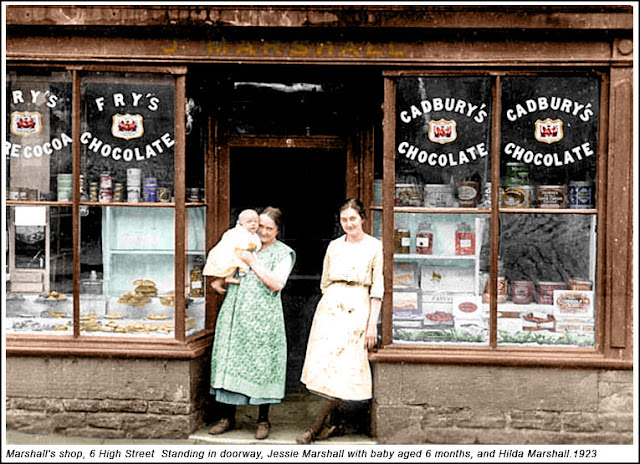
Marshall's Bakers shop was also on High Street, New Mills. The business later moved to premises on Market Street.
Spicer's Farm was near to Kishfield Bridge in Kettleshulme.
The view from the waiting room at New Mills Central probably in the 1970s
A gathering of motorists in Edwardian New Mills
The Pack Horse in Mellor Road above New Mills. Photographed c1954 by Peter Thompson.
The pram race was a popular charity event in Whaley Bridge. Here is one of the 1974 entrants.
Picnic parties welcome. The Railway Hotel, Buxton in the 1920s.
The suspension bridge across Fernilee Reservoir. This was erected in 1935, just before flooding of the valley to replace a former roadway and ford and to allow walkers to cross from one side of the valley to the other. It was dismantled about 1967.
The Royal Oak at Taxal in the 1940s. The name was later changed to The Chimes to reflect the proximity to Taxal Church. The pub closed in the 1980s although a sign "The Chimes" still hangs from the wall.
Looking towards Terrace Road in Buxton. Traffic and dress apart, this scene has not changed greatly.
Turner's confectioners shop in Whaley Bridge. Not the St. John's Ambulance first aid box next to the Mechanics Institute.
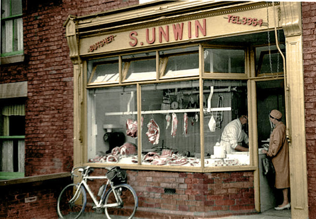
Unwin's. A traditional butcher's shop on Church Road, New Mills.
Whaley Bridge Station in 1958. A few passengers await the train towards Manchester.
The bridge over the River Goyt at Whaley Bridge. At the time of this photograph, the river marked the boundary between Derbyshire and Cheshire.
A goods train from Buxton passes through Whaley Bridge. The location is just behind the Cock Hotel. The track in the foreground led to Shalcross Sidings at Horwich End.
The White Hart at the corner of Dyehouse Lane and Bridge Street in 1954. A North Western bus approaches. Route 94 ran between Birch Vale and New Mills via Thornsett.


No comments:
Post a Comment