
We have created a number of village scenes using Sketchup software. These 3D models allow us to take a look at buildings that no longer stand or have been altered over the years. Here is a selection:


The garage on Buxton Road as it appeared c 1960. At that time it was owned by Start Motors. The row of cottages was sometimes known as "Office Row" as it included the office of one of the local collieries. The window at the end, facing Yeardsley Lane, was usedto pay miner's wages of a friday evening.
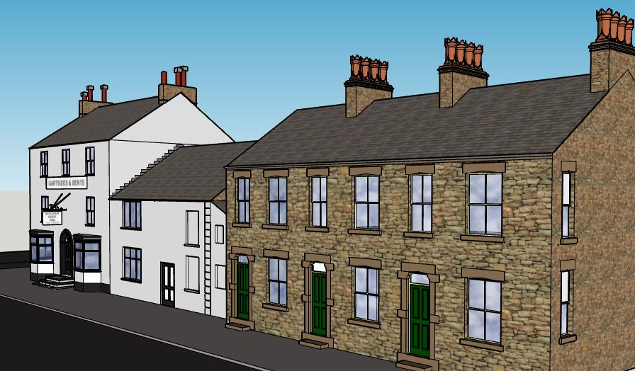


53 to 65 Buxton Road. The "Corn Store" was at that time used by Scowcroft's grocer's next door for storage. The building which is deceptively of three storeys has served many roles during its time and is now of course the village "chippy".
57 Buxton Road, was for many years, an ironmongers and until 1956 was owned by Bennett's. It later hosted a video shop and for a while housed a haulage business.
Number 65 was well known as the village wool shop. It had been haberdashery and draper's long before the Wild sisters took over in 1941.


This row included Furness Vale Post Office. We have illustrated it before it was extended tp incorporate the gabled fronted building next door. 71 Buxton Road was originally a confectioners before Hill's took over by the early 1940s and sold groceries. Jane Ramwell was the final shopkeeper. Number 69 at the corner of Old Road was at one time a fried fish shop and prior to that may have been a drapers. It became a newsagent's in 1957, first owned by Brian Smedley, then Smalleys and finally Geoff Hill.
The building at the rear, 2 Old Road has hosted many differrent businesses. Once known as Rowley's Buildings, the upper floor was a reading room in the early 20th century. Between the wars it was occupied by a tailor and later by Eastwood's cash registers. The ground floor was a separate entity and was used by Timothy Beard as a stable. He was the "night soil man" but also used his cart for house removals and general carting. It was later occupied by a greengrocer, by a cycle repairer and by a cobbler.


This model of St.John's Church has yet to be completed. We will be able to show an impression of the appearance had the proposed tower been constructed.

The Methodist Chapel on Station Road. Now converted to housing, Originally constructed in 1840, the building was twice extended.

Alongside 264 Buxton Road, these was once a lean-to shop. Originally a haberdasher's, this later became a hair stylist's salon. We are usure when this was built but certainly existed in the 1930s. The business probably closed about 1980.

Across the road, at the corner of the track leading to Carr Farm, was a small wooden shop. This was a baker's and confectioners. This was in business from at least 1910 until closing in the early 1960s

The Nat West Bank moved to 99 Buxton Road in 1933. Previously this had been the sweet shop of Mr and Mrs Middleton. The bank was onlyopen three days a week for limited hours and closed in 1974. Next door but one at 95 Buxton Road, the antiques shop had previously been a bakers and confectioners, known locally as "The Cafe".

Our model of Furness Vale Station and the Station Hotel shows the scene in the early 1960s. The station featured waiting rooms on both platforms and a manned booking office.


The level crossing gates were opened by turning a large wheel in the signal box.

The Station Hotel, now The Crossings, incorporated a lock up shop. This was usually occupied by a confectionery business. The building opposite was orignally the Station Master's House.


The Furness Vale Tollbar was at the bottom of Station Road, adjacent to the bridge over the River Goyt. Although there are no known photographs of the cottage, we do know its dimensions for they are clearly shown on the Tithe Map. This impression of the tollbar and cottage is based upon the design of another cottage built by the Thornsett Turnpike Trust who managed this road.
No comments:
Post a Comment