Both the original span and the extension are seen in this photograph taken in the 1940s. The locomotive is No 3271 heading south with a train of empty wagons. A group of three train spotters sit at the trackside. Big Tree Farm is on the hillside
Les Footitt recalls the bridge from the late 1960s:
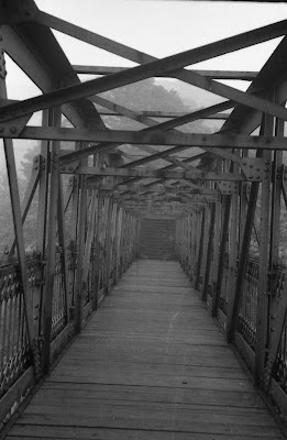
"It brings back the memory of being with my brothers and friends in the late 1960s. We would always be out exploring up at the disused sidings. As you approached the bridge from Waterside , you would walk through the tunnel to the bridge and the then turn left to go up about 10 stone steps, then turn right up another flight of stone steps until you were on the wooden walkway across to Big Tree. Well, it was at the bottom of the steps that we found that the earth had fallen away revealing a small hole and we could see that it was hollow inside. We returned at a later date with torches and scraped a bit more soil out until we could squeeze through on our bellies into what was to us a secret cave. We went there on numerous occasions to play in the “cave” until we eventually got too big to squeeze through the gap. I think the bridge was demolished in the mid 1970s".
Les also describes the far end of the bridge:
You actually came down a flight of about 10 stone steps from Big tree on to the wooden walkway. so if you were to walk along the bridge from Waterside end towards the Big Tree end all you saw were the stone steps as if it was a dead end and no exit until you were at the bottom of the steps.
The bridge has long been demolished but following the path from Big Tree Farm still leads to a descending flight of steps. The path crosses the site of the sidings at ground level and then passes under the remaining railway tracks through the original tunnel.
Neil Ferguson-Lee's photographs show the view along the bridge with the rising flight of steps at the far end.

Below is the tunnel under the main railway line. This is the view towards Waterside.


