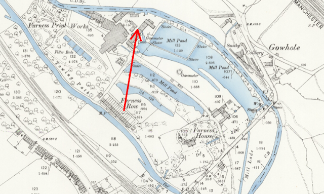
Furness Vale Printworks once had several mill ponds fed by a mill lade from the River Goyt. These appear in a number of our archive photographs but as several have now been filled, it is not easy to identify them.
Peter Gorry, who is familiar with the locality has been comparing these pictures with historic maps and these are his findings.
Your blogspot: Thursday, 3 January 2013 Furness Vale Printworks has some great photos. The 5th one has a caption:
"The mill lodges viewed from station road. These have long since been filled in and little sign remains of them."
I’m certain this is actually the view from the back gardens of Lakeview cottages (old Furness Row, adjacent to the canal). Direction shown on 1898 map below. The house at the very left of the picture is 1 Bank View (current owners of the industrial park). You can see it clearly in picture 3 in the same set (woman on Bank view, and the middle millpond to her right. The very far millponds are no longer there (now Trident Foam) but the two closest ones are in the grounds of Lakeview House. Although the nearest pond has been substantially filled in the middle one is still complete and can be seen as you drive down Calico lane. Both 1 and 3 Bank View look directly along its length.
The sepia picture (below) is clearly the square walled
millpond just to the right of the arrow head (now Trident Foams). I’m
not sure when these millponds were decommissioned, they are still shown
on a 1945 map (which is far less detailed - but it was world war 2!)
I’ve
been investigating the two weir pictures. The one with the Mill Lade
must be the one shown here. The left hand small island and two Mill Lade
channels are no longer there - they have been built over as can be seen
in Google. The right hand island is still there.
I think the bend of the river is actually the channel going round the
small island (red arrow). The building in the distance on the left of
the picture would be Meadows Farm.
The other weir picture in the snow is more difficult to pin down.
The surrounding land is steeply rising and has houses above. This could
certainly be the Gowhole buildings. But the weir is steep and enters the
water at 90 degrees to the flow direction. However, careful study of
the maps produces a probable location. I believe it is the weir to drain
the long millpond along the right side of calico lane (now long gone),
yellow arrows for water flow. This would have been substantially higher
than the river Goyt, so the weir marked by the red arrow would simply
empty water into the narrow channel sloping down to the river at Goyt
Bridge.
Note: The sepia picture which Peter refers to shows the mill pond drained for inspection. This was carried out to prevent silting.
The following update from Peter is dated 12th December.
I’ve been puzzling over the recent weir photo you sent. It is
obviously the same weir, and the wall of the bricked-in millpond is
visible, but there seems to be little in the way of buildings where the
mill is. Also there is a substantial tree line on the left side
extending into the water. But this must be the right side of Calico lane
- which is usually pretty barren of trees in photos - e.g.
Also,
it is a single chimney cottage at the end, which isn’t part of the
present mill. I had thought the picture was a later one, but the sepia
photo saves the day. The single chimney cottage is clearly visible. Also
the square tower with sloping roof can just be made out in the picture
if enlarged. It seems behind the cottage, but I think this is just the
perspective from the weir.

The
large scanned map (Cheshire XX.16) has revealed an unexpected
bonus on further investigation. I was trying to establish it’s scale
when I found that the legend at the bottom shows 2600 feet - and is 2600
pixels long! The scan has carefully been set to 1 pixel = 1 foot. So a
100 pixel line is 100 feet on the ground, a real bonus to have such a
simple measurement scale on an old map.
Finally,
the Cheshire tithe maps can have different overlays, one is aerial
imagery from 1971-73. This clearly shows that the brick mill pond still
existed then. Given how recent this is I’ll see if I can get any
further info from the current owners


No comments:
Post a Comment