Tuesday, 25 December 2018

Furness From The Air

Here's a high quality aerial view of the village from 1974. The butcher's shop, at this time owned by James Lavin looks open for business as the shop blind is drawn. On the other corner of Station Road is Barbara Griffith's shop. The building that was to become the Imperial Palace restaurant was at that time, the offices of Riddick's Builders. There are a number of cars parked at the back of the office but note how quiet the roads are. The buildings of Riddick's yard may be seen on Charlesworth Road. This is the land, like a small wood, that became Charlesworth Close.
A train is approaching from Buxton, a three coach diesel unit. The fields beyond the station are still to be built on.There on the other side of Station Road is the Scout's hut.
In the brickyard is the old "bottle" kiln. Bricks and firebacks are still in production and stacks of them await despatch. The foundations can be seen for the first of the newindustrial sheds.
The Football Field looks in a very poor condition but the bowling green and tennis court are well maintained.

Take a close look at this photograph, there is so much to be seen


Thursday, 20 December 2018

Chinley Tales

Chinley 


Hidden away behind the high hills of North Derbyshire and served only along a by-road, Chinley feels remote.  The fact that one can be in Manchester in 30 minutes by a fast train has turned Chinley into something of a commuter village. It is the presence of the railway that caused this community to grow from a small hamlet, for this was once a major railway junction with a station of six platforms. London trains regularly called here as did services to Sheffield, Derby, Buxton, Manchester and beyond. The station once boasted a refreshment room and bookstall as well as the usual waiting rooms and booking offices. There was a large goods yard, a turntable and two signal boxes. The station now has a train every two hours and passengers wait in a glazed shelter on the single island platform.

Wednesday, 19 December 2018

The Australian Bungalows.


Furness Vale in Derbyshire takes pride in it's three "Australian" bungalows.  These were built, according to which version you hear, either by a retired sea captain or by a returning emigree. Whichever story is true, it seems that the builder was nostalgic for the architectural styles of New South Wales or Victoria.  


Originally these homes all had Australian names.  The nearest in the photo above was called  "Tarramia" and was probably built in 1898. The farthest, built at the same time still retains it's name "Yarrawonga". "Boominoomina" in the middle wasn't built until 1904. 

The three properties were offered for sale at auction in 1911. The owner then lived at "Yarrawonga" and Boominoomina was rented, furnished for £1 per week; probably quite a high price at that time.

The middle bungalow had at first been occupied by Mr Knowles, owner of the local coal mine and brickyard. This was at the time that his new house further up the road was being built. The mine was at the rear of these homes. Although it was worked for a period of more than two centuries, it would never have been much in evidence. At it's peak only 30 men worked underground. All that existed on the surface was a small brick building which also housed the adit and alongside, a small wooden pithead over a shaft.

 
"Yarrawonga"
"Tarramia", later re-named "Garswood"


1927  - The cast of the Methodist Sunday School play gather in the garden.

Sunday, 18 November 2018

A Walk Along The Towpath


We will start our walk along the towpath at Bank End Bridge. We're in New Mills here but it is an appropriate place to begin.


A track leads down from the A6, crosses the railway and then the canal bridge No 29.  This was an old pack horse route from Higher Disley to Goytside and Low Leighton. On the Newtown sidee of the Bridge, opposite the towpath was Bank End Wharf. This served the quarries which were on the other side of Buxton Road. If the footpath is followed downhill, it reaches the River Goyt and Goytside footbridge. This has long since been been a crossing point.  Just through the gate on the left is the outlet from a sough. This tunnel drained water from the Bank End Colliery workings which were mostly located around the area of the quarry. Until a few years ago, there was no protective grille and the tunnel was often used to access the mine.


Follow the towpath towards Furness Vale and after about 300 metres we reach the site of Bank End Colliery Engine House on the opposite bank. There was an 80ft deep shaft here a little distance from the canal. Tubs of coal would be raised from the workings and taken on a short track to a canal side tippler where narrowboats were loaded. The colliery closed in 1921.  Maps of the local colliery working show a lengthy tunnel from the field opposite Yeardsley Hall Barns to Bank End Engine house. This is marked on some maps as a roadway but is more likely to have been a drainage sough and probably continued down to the River Goyt.

Saturday, 1 September 2018

The Buxton Train

This digitally coloured photograph shows a Buxton train arriving at Furness Vale in 1959. At this time, diesels had taken over most services although a few steam trains survived.  The locomotive is No 42365
Despite the nostalgia for "better times" we have to remember that until the coming of the diesel railcars, services were much poorer than today.  The 1947 timetable below shows a 4 hour period between afternoon trains to Buxton and only a two hourly service to London Road.


The Lightning Tree

Diglee Farm stands on the hillside, high above Furness Vale. It's the oldest farm in the village and the original farmhouse, which had accommodation for animals on the lower floor, still stands. The building is no longer occupied however, having been superseded by a more modern house opposite.


This early photograph shows the Trueman Family outside the farmhouse.

In the field below the farmhouse,  a dead tree appears to have been hit by lightning.  The cart too, has seen better days.
A watercolour painting.

Ringstones

Just below Ringstones Farm in Furness Vale and close to the caravan park, is this dilapidated farm hut.  Despite having lost most of its roof, it still manages to survive in an exposed location.
This is a watercolour painting.


Marple Locks

The flight of 16 locks at Marple raise the level of the Peak Forest Canal by 64 metres. The canal was opened in 1796 but the locks were not completed until several years later due to lack of funds. A temporary tramway connected the two sections of canal.

This watercolour painting depicts a lock on the lower part of the flight.


Thursday, 30 August 2018

Providence Chapel

Providence Chapel in Mellor Road, New Mills was built in 1823. Due to lack of funds, having purchased the land, members of the congregation built the chapel themselves. At first it was too large and a section of the building was used for a time as a barn. It is pictured in this watercolour in the early 20th century


The Mechanics

The Mechanics Institute, Whaley Bridge is home to the Public Library, Town Council, Reading Room and Function Rooms.
A watercolour painting.


Thursday, 5 July 2018

THE KETTLESHULME GUNPOWDER HUT


Marie Cunningham has been researching a footpath leading westwards from Neighbourway Farm in Kettleshulme and in doing so has discovered some fascinating local history. 

Turn down Side End Lane, alongside St.James Primary School, and after about 150 metres a narrow road leads off to the right. This road only serves a few farms and eventually peters out. About half way along is Neighbourway Farm which is also known as Green Low Heath. Opposite the farmhouse is a short track leading across the field and this is the start of an alleged footpath leading westwards across Todd Brook, towards Charleshead Farm. Although the path appears on some maps, its route is uncertain and the right of way has never been enforced. This little road is just over 150 metres long and at the end is a small windowless brick built structure which had a slate roof which has fallen in but the walls are still standing. Not much is known about the hut but Peter Garlick of Neighbourway has always known it as the Gunpowder Hut. The Garlick family has lived at Neighbourway since c1930.  Jim Etchells who lived close by at Near Carr told Peter that a member of the Hewitt Family lived at Charleshead and collected gunpowder from the hut. He stated in 1993 that the gunpowder hut was used up to the time of the first World War.
 The Hewitt family were involved in mining in the area. 
 Jas Hewitt lived at Green Low Heath (Neighbourway farm)  Kettleshulme. (Kelly's Directory of Cheshire 1892, the 1901 census and the Finance Act (1910) record of 1913.  
 John Hewitt lived at Winters Close, Rainow. (The 1910 Finance Act records)
 Margaret Hewitt was at Dales Farm c1913
 Sydney Hewitt was an agricultural implement dealer in Kettleshulme - no location given (Kelly's directory of Cheshire 1914)
 William Hewitt was an iron steel and implement merchant and in 1906 was Kettleshulme sub-postmaster (Kelly's directory 1906) 
 
Dales farm, as well as being the post office, is the location of the shop which Marie believes was where the gunpowder was sold. It's a stone built low level building at the end of the house which fronts the main road opposite the school but it is two storey at the rear. Raymond Lomas can remember c1950 the paraffin cans etc which had been left behind when the shop closed 
 
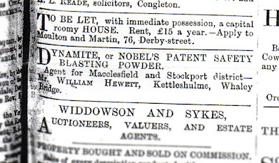
Could Mr Hewitt have lived at Greenlow Heath and built the gunpowder hut because he was an agent for the Nobel Dynamite Company ?


Marie has found a snippet of information in a book "Rainow Caught in Time" written by the Rainow History Group it reads 
"In June 1878 there was an experiment with dynamite at the home of Mr Sutton in Tower Hill.  Several unsuccessful attempts had been made by a local miner to blow up a very large tree root with ordinary blasting powder. 
Mr Hewitt of Kettleshulme, agent for the Nobel Dynamite Company experimented with the use of dynamite and successfully blew it to pieces"

On the other side of Todd Brook is an area of marshy land which was used to grow willow for basket making. The man-made clay pans and drainage channels used for growing the willow can still be seen on the ground but once again more detail is not known

The Hewitt family were long associated with Furness Clough Colliery as well as managing Castedge Mine in the Goyt Valley and the pits at Charleshead.

Dynamite was the invention in 1867 of Swedish chemist and inventor, Alfred Nobel (1833 - 1896), just one of his 355 patents. On his death, most of his wealth was left in trust to fund the Nobel Prize. 
The British Dynamite Company was established by Nobel in Ayrshire in 1871. At its peak it employed nearly 13,000 workers. The name changed to Nobel's Explosives Ltd in 1877 but the name disappeared through mergers at the time of the First World War although it was resurrected in 1920.


Marie is still researching the subject of both the Gunpowder Hut and the footpath and would appreciate any further information. Please write to furnesshistory@gmail.com


from a Macclesfield newspaper of June 1878

Location of Neighbourway and the Gunpowder Hut

Tuesday, 19 June 2018

Canal Bridge and A Beerhouse

A newly acquired photograph ( copies are available on Ebay).  
The picture is undated although it is earlier than 1924, the year when the bridge was rebuilt. Reconstruction took over a year during which time the road was closed. A  rickety footbridge allowed pedestrians to cross. 

The building next to the bridge had been a beerhouse. Strangely it had two names both of which were in official use at the same time. The pub, The Jolly Sailor/Traveller's Call had closed in  1908, the license renewal having been refused on grounds of disorderly conduct.  This was a common reason given by the police when  a  pub was closed under the 1904 Licensing Act. This was a measure to reduce the number of pubs and beerhouses in Britain and hopefully reduce drunkenness. Also known as the Compensation Act because it provided for a payment to the licensee for loss of earnings. Note that the extension to the side of the house is of 2 storeys and much longer than at present. It is not known when it was rebuilt. It is now the White Cottage,a holiday home.

In the foreground is the stone parapet  of the Furness Vale Aqueduct.  This carries the canal across Furness Brook and also over an abandoned road. Look under the bridge and you will clearly see the roadway at the side of the brook. The Mid 19th century tithe maps show that this was a continuation of Old Road and passed under the canal before joining present day Station Road in the vicinity of Calico Lane. It was probably abandoned when the present alignment of Station Road was constructed.  This, together with Marsh Lane,had been a turnpike road managed by the Thornsett Turnpike Trust.  The tollbar was at the bridge over the Goyt. Look at the parapet and you will see a variation in the masonry where the toll cottage once stood.   John Warren's diary records an occasion when the son of the tollkeepers, the Southern Family, fell from the "battlements" of the bridge onto the rocks below.

The ground to the right of the parapet, where a modern house now stands is said to have been at one time a village tip.


Monday, 12 March 2018

Monday, 5 March 2018